

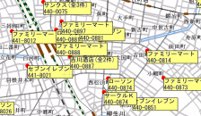
Thematic Map
Thematic Map Function is the main function in GIS Engine, which also exist in our MapQuestDotNET.
Gradation and hatching pattern (and other functions) are used to generate a nice and user-friendly thematic map.
This certainly supports presentation and data analysis.
Moreover, more than one thematic map can be displayed at the same time (i.e., bar chart together with density pointing, and so on).
Label
→ Automatically Position Adjustment
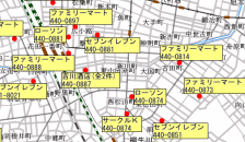
The display of labels is automatically adjusted at the optimum position with no overlap.
→ Simplification & Enhancemen

The thematic labels were formerly coded in a few lines of code, but for more simplicity the code is rewritten into only one line, with function of no overlapping of the labels.
Also, the label can be displayed along the line (as shown in the sample captures).
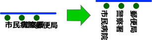
Space Analysis
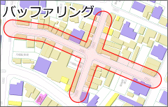
The logical operations of shapes (polygons) are operated to create a buffering (free space).
Voronoid Diagram and Drive Time Polygon are able to be drawn and used for information analysis.
Print & Output an Image in specific area
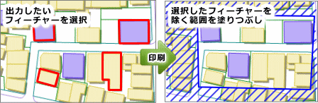
The area only covered the selected features will be printed/outputted. There is no need to print out the whole map.
Mouse Function
The embeded standard functions used in the map, such as scrolling, zoom-in & zoom-out, search & retrieve, editing, and measurement, are readily functional. The speed of scrolling, size enlargement and its ratio, can be easily adjusted in properties setting. There is no need for new programming.

Export Function
MapQuestDotNET provides a library that enables the map data to be exported as an output directly into DXF Format (AUTOCAD) and ShapeFile Format.
*The copyright of map data is owned by the map-data company.
The company permission is needed before the output is exported or taken out.

Thematic Map
Search & Measurement
- Search at the mouse clicked position,
- Search in a particular area, etc.
- Area measurement,
- Distance measurement, etc.
Advanced Search
- Search with conditions
- Search result filter
Thematic Map SQL Condition
- Specify the SQL condition for thematic map.
Line Types Flexible Setting
Many line types such as solid, dashed, special, pattern lines, are combined to represent complex linetype styles such as DM. Not only the arrows but also symbols can be set at the starting and ending points.

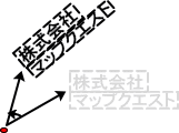
Rotation Method of Text and MultiText
The rotation is functioned at the center of a string or at a reference point.
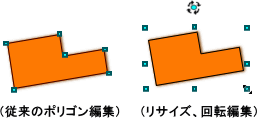
Resizing and Rotation of Polygon
Polygon can be resized and rotated in Edit Mode.
Individual Style
The color or line type style can be set for each figure, one by one. The same layer of buildings can also be represented by different styles.

Print
The map can be printed via the printer by specifying the range of printing area in the map and paper range, or export to image file, such as bitmap, so that can be used further in MS Word or MS Excel.

Realtime Projection
Realtime projection will be converted and displayed in realtime. Moreover, Japanese Geodetic System and World Geodetic System can be handled together at the same time.

Surround Scroll
No need to use mouse wheel or mouse button.
Just only move the mouse around the map, it will be scrolling.
There is no need to use mouse wheel or mouse button, many operations can be performed.

Support for Cartesian Coordinate, Longitude, Latitude
The specified coordinates (X,Y), the latitude and longtitude, are able to view on the map display. The conversion of latitude and longtitude of Japanese Geodetic System to World Geodetic System can also be done.

Map Data Direct Reading
The direct reading program (feature provider) is used instead of map data conversion. (There is no need for the customer to convert the file format because we alreay provide the general format readers.)
For example, SHAPE data comes along with direct readable SHAPE provider.
